
Trails and Overlooks
Lewis Pond. Photo by Sharon Lindsay
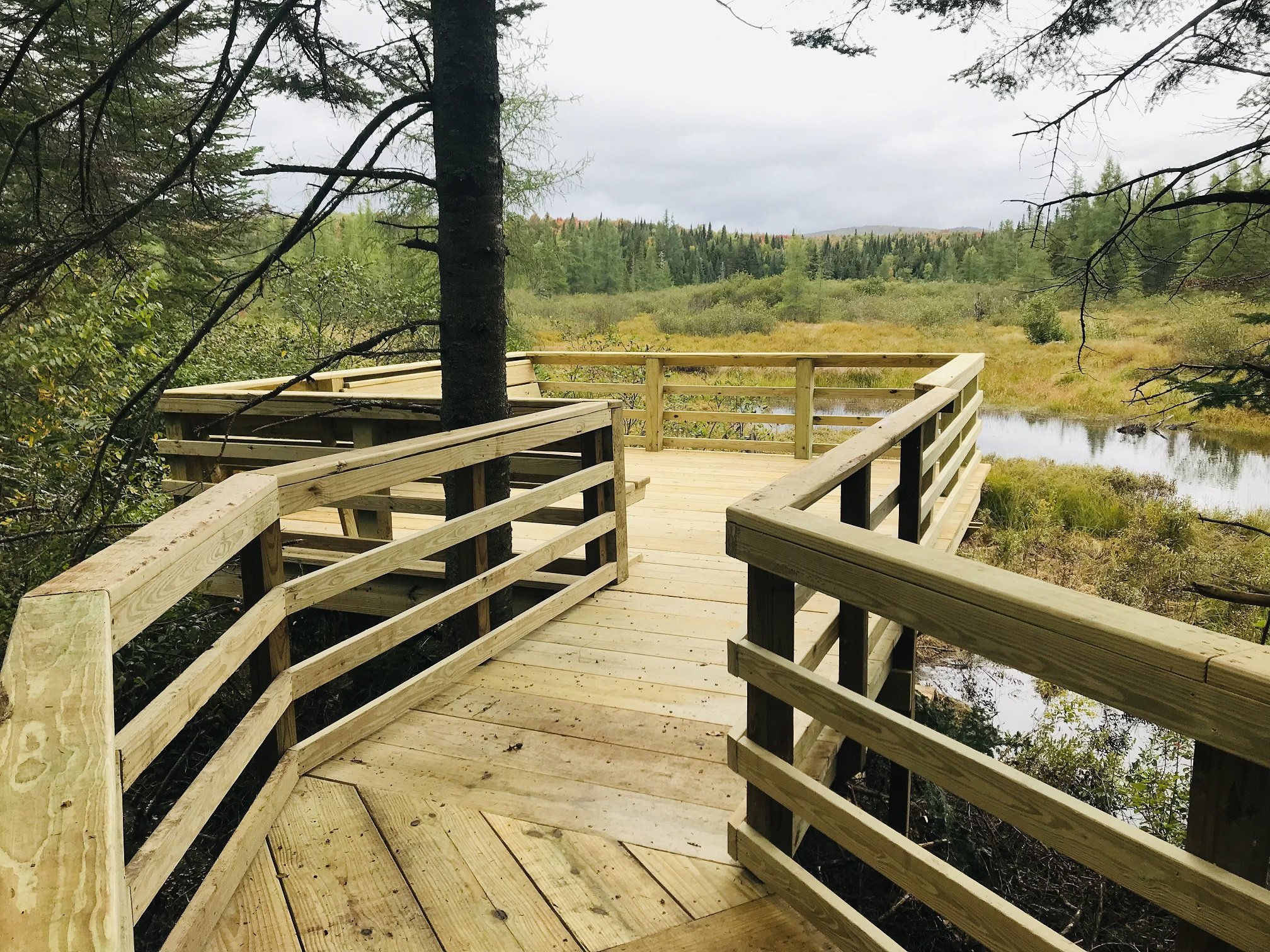
Mollie Beattie Bog: Located on Four Mile Road and recognized as a State Significant Site, Mollie Beattie Bog is among the most significant black spruce woodland bogs in Vermont. The self-guided, newly renovated, 200-foot, fully accessible boardwalk and trail include signs illustrating bog formation, the interesting rare plants that inhabit the black spruce bog area, and the legacy of the late Mollie Beattie. The 76-acre bog, donated to the U. S. Fish and Wildlife Service by Champion International, was named after the first female director of the Service, a former resident of Vermont. Visitors to the interpretive site are requested to remain on the boardwalk to avoid disturbance to the sensitive wetland habitat.

Mollie Beattie Boardwalk and Observation Platform
Photo Credit: USFWS
Nulhegan River Trail: A 1-mile interpretive loop that originates at the Visitor Center, this is a rustic trail with stone steps and "bog" bridges. This trail is accessible year-round and is suitable for snowshoeing. Members of the Northwoods Stewardship Center’s Back Country Trail Crew and the Nulhegan Basin’s U.S. Youth Conservation Corps (YCC) have done an excellent job working on this trail, helping to create a short interpretive walk that offers visitors a chance to experience the uniqueness of the Basin without driving into the Refuge if short on time.

Patio Behind Visitor Center, overlooking the Nulhegan River Trail location
Photo Credit: USFWS
The Lewis Pond Overlook:
Located on the north end of the Lewis Pond Overlook Road, this overlook provides a panoramic vista of Lewis Pond and the surrounding landscape. The Overlook has a small, fully accessible parking area and a short trail leading to an observation area. Lewis Pond Overlook is the trailhead for the Gore Mountain Trail (formerly known as the Lewis Pond Trail)
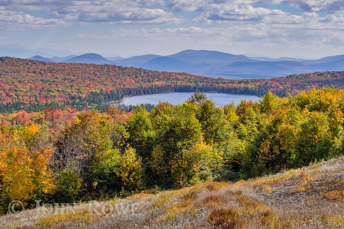
View from the Lewis Pond Overlook
Photo Credit: John Rowe
Gore Mountain East Trail: The trail, formerly known as the Lewis Pond Trail, begins at the Lewis Pond Overlook parking area and follows a section of woods road that is used in winter by snowmobiles for a short distance before entering the woods on the right. The trail is 2.3 miles from the overlook to the fire warden’s cabin. from Trailfinder
The Gore Mountain East Trail accesses The Gore Mountain Trail: Part of the Kingdom Heritage Trail, the Gore Mountain Trail connects the Nulhegan Basin Division to downtown Island Pond.
The Kingdom Heritage Trail was first conceived in 1998 but didn't become reality immediately.In 2001, the Green Mountain Club became corridor manager for hiking trails on the former Champion Lands, and then in 2010, NorthWoods Stewardship Center crews constructed the first sections of the trail on the north side of Middle Mountain. With support of the partners- Weyerhaeuser, Sweet Tree, the Town of Brighton, VT Department of Forests, Parks and Recreation, US Fish & Wildlife Service, Nature Conservancy, and Vermont Land Trust- the Kingdom Heritage Trail system now rambles over 20-miles of Northern Forest terrain.


Kingdom Heritage Trail Map Two
North Branch Trail: A 4-mile loop bordering the North Branch of the Nulhegan River, this is also a rustic trail and is accessible year-round from a parking area on Vermont Route 105. In addition to snowshoeing, certain segments are also suitable for cross-country skiing.

Burls on Tree on North Branch Trail - What do you see?
Photo Credit: von Alt
View of the North Branch of the Nulhegan from the Trail
Photo Credit: von Alt
Yellow Branch Boardwalk and Observation Platform:
The NorthWoods Stewardship Center’s Pro-Crew constructed an accessible elevated boardwalk overlooking the Yellow Branch of the Nulhegan River. The new boardwalk is part of the existing auto tour route at the Nulhegan Basin Division.
Yellow Branch Boardwalk and Observation Platform
Photo Credit: USFWS

Black Branch Observation Platform
Photo Credit: USFWS
Black Branch Boardwalk: The Black Branch Boardwalk is a self-guided, 250-foot, wheelchair-accessible boardwalk. The elevated boardwalk starts at the Stone Dam Road near the Black Branch Bridge and gradually meanders through a softwood forest to a large observation platform. The observation platform overlooks the Black Branch of the Nulhegan River.
Stone Dam Overlook: The NorthWoods Stewardship Center’s Pro Crew built this viewing platform at the Stone Dam parking area. The observation platform overlooks the Nulhegan River.

NorthWoods Stewardship Center’s Pro Crew on the Viewing Platform They Just Built Along the Nulhegan River at
Stone Dam Parking Area
Photo Credit: USFWS